.
Plugin Spatial Query
The  Spatial Query Plugin allows you to make a spatial query
(i.e., select features) in a target layer with reference to another layer. The
functionality is based on the GEOS library and depends on the selected source
feature layer.
Spatial Query Plugin allows you to make a spatial query
(i.e., select features) in a target layer with reference to another layer. The
functionality is based on the GEOS library and depends on the selected source
feature layer.
Gli operatori spaziali sono:
Contiene
E’ uguale a
Sovrappone
Attraversa
Interseca
E’ disgiunto
Tocca
E’ contenuto
Come usare il plugin
Come esempio: trova le regioni dell’Alaska che contengono areoporti. Sono necessari i seguenti passaggi:
- Start QGIS and load the vector layers regions.shp and airports.shp.
- Load the Spatial Query plugin in the Plugin Manager (see
La finestra di dialogo Plugins) and click on the
Spatial Query icon, which appears in the QGIS toolbar menu. The plugin
dialog appears.
Seleziona il layer regions come layer principale airports come layer di riferimento.
Seleziona l’operatore ‘Contains’e clicca [Apply].
Ora avrai una lista di risultatu IDs dall’interrogazione, come mostra la figure_spatial_query_1
- Click on
 Create layer with list of items.
 - Select an ID from the list and click on
 Create layer with selected.
 - Select ‘Remove from current selection’ in the field
And use the result to
 .
. - You can
 Zoom to item or display
Log messages.
Zoom to item or display
Log messages. - Additionally in Result Feature ID’s with the options ‘Invalid source’ and ‘Invalid reference’ you can have a look at features with geometries errors. These features aren’t used for the query.
Figure Spatial Query 1:
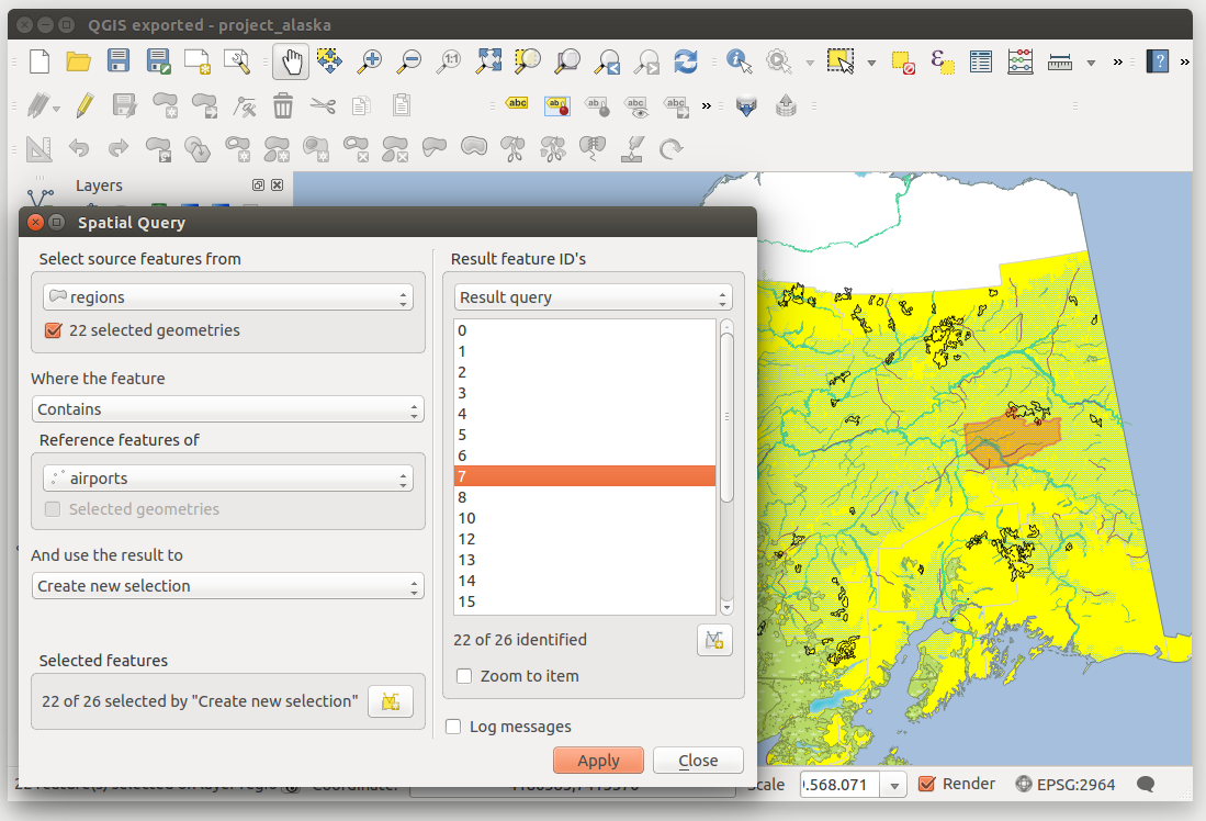
Spatial Query analysis - regions contain airports