QGIS 환경 설정
QGIS is highly configurable. Through the menu, it provides different tools to:
 Options…: set global options to
apply in different areas of the software. These preferences are saved in the
active User profile settings and applied by default
whenever you open a new project with this profile.
Also, they can be overridden during each QGIS session by the project
properties (accessible under menu).
Options…: set global options to
apply in different areas of the software. These preferences are saved in the
active User profile settings and applied by default
whenever you open a new project with this profile.
Also, they can be overridden during each QGIS session by the project
properties (accessible under menu). Interface Customization…: configure the
application interface, hiding dialogs or tools you may
not need.
Interface Customization…: configure the
application interface, hiding dialogs or tools you may
not need. Keyboard Shortcuts…: define your own set of
keyboard shortcuts.
Keyboard Shortcuts…: define your own set of
keyboard shortcuts. Style Manager…: create and manage symbols and
color ramps.
Style Manager…: create and manage symbols and
color ramps. Custom Projections…: create your own
coordinate reference systems.
Custom Projections…: create your own
coordinate reference systems.
옵션
Options 대화창을 통해 QGIS에 대한 몇몇 기본 옵션을 선택할 수 있습니다. 메뉴 옵션을 선택하십시오. 사용자의 필요에 따라 옵션을 수정할 수 있습니다. 일부 변경 사항은 적용되기 전에 QGIS 재시작이 필요할 수도 있습니다.
사용자 고유 옵션을 사용자 지정할 수 있는 탭들에 대해 다음 항에서 설명하고 있습니다.
참고
Plugins can embed their settings within the Options dialog
While only Core settings are presented below, note that this list can be extended by installed plugins implementing their own options into the standard Options dialog. This avoids each plugin having their own config dialog with extra menu items just for them…
일반 설정
Locale Settings
Check
 Override system locale if you want to use a language
different from your system’s and pick the replacement in Locale to use
instead combobox.
Override system locale if you want to use a language
different from your system’s and pick the replacement in Locale to use
instead combobox.Information about active system locale are provided.
응용 프로그램
Select the Style (QGIS restart required)
 and choose
between 〈Oxygen〉, 〈Windows〉, 〈Motif〉, 〈CDE〉, 〈Plastique〉 and 〈Cleanlooks〉;
and choose
between 〈Oxygen〉, 〈Windows〉, 〈Motif〉, 〈CDE〉, 〈Plastique〉 and 〈Cleanlooks〉;Define the UI theme
. It can be 〈default〉 or 〈Night Mapping〉;Define the Icon size
;Define the Font and its Size. The font can be
 Qt default or a user-defined one;
Change the Timeout for timed messages or dialogs
;- Hide splash screen at startup;
- Check QGIS version at startup to keep you informed
if a newer version is released;
- Modeless data source manager dialog to keep the
data source manager dialog opened and allow
interaction with QGIS interface while adding layers to project;
- Use native color chooser dialogs (see 색상 선택기).
프로젝트 파일
Open project on launch
(choose between 〈New〉,
〈Most recent〉, 〈Welcome Page〉, and 〈Specific〉). When choosing 〈Specific〉 use
the … button to define the project to use by default. The 〈Welcome Page〉
displays a list of recent projects with screenshot.- Create new project from default project 를 선택하면 Set current project as default 또는 Reset default 가운데 하나를 클릭할 수 있습니다. 사용자 파일을 탐색하고 사용자가 직접 정의한 프로젝트 템플릿이 있는 디렉터리를 정의할 수 있습니다. 해당 템플릿은 메뉴에 추가됩니다. 먼저 Create new project from default project 를 활성화한 경우, 프로젝트 템플릿 폴더에 프로젝트를 저장하십시오.
- Prompt to save project and data source changes when
required to avoid losing changes you made.
- Prompt for confirmation when a layer is to be removed
- Warn when opening a project file saved with an older
version of QGIS. You can always open projects created with older version of
QGIS but once the project is saved, trying to open with older release may fail
because of features not available in that version.
Enable macros
옵션은 프로젝트 이벤트에 대한 액션을 수행하기 위해 작성된 매크로를 처리하기 위해 만들어졌습니다. 〈Never〉, 〈Ask〉, 〈For this session only〉 그리고 〈Always (not recommended)〉 가운데 선택할 수 있습니다.
시스템 설정
SVG 경로
Path(s) to search for Scalable Vector Graphic (SVG) symbols 를 추가하거나 삭제합니다. 피처 심볼 또는 사용자 맵 조판 장식에 이 SVG 파일을 쓸 수 있습니다.
플러그인 경로
Add or Remove Path(s) to search for additional C++ plugin libraries.
Documentation paths
Add or Remove Documentation Path(s) to use for QGIS help. By default, a link to the official online User Manual corresponding to the version being used is added. You can however add other links and prioritize them from top to bottom: each time you click on a Help button in a dialog, the topmost link is checked and if no corresponding page is found, the next one is tried, and so on.
참고
Documentation is versioned and translated only for QGIS Long Term Releases (LTR), meaning that if you are running a regular release (eg, QGIS 3.0), the help button will by default open the next LTR manual page (ie. 3.4 LTR), which may contain description of features in newer releases (3.2 and 3.4). If no LTR documentation is available then the testing doc, with features from newer and development versions, is used.
QSettings
사용자가 어떤 sec_customization 사항이라도 만들었을 경우 Reset user interface to default settings (restart required) 옵션을 통해 초기화할 수 있습니다.
환경
이제 Environment 그룹에서 (QGIS의 시스템 환경 변수 그림 참조) 시스템 환경 변수를 살펴볼 수 있고, 많은 변수를 설정할 수 있습니다. 이 옵션은 맥OS처럼 GUI 응용 프로그램이 사용자의 셸 환경을 반드시 상속하지는 않는 플랫폼에서 유용합니다. SAGA, GRASS 같은 공간 처리 툴박스가 제어하는 외부 도구 모음을 위한 환경 변수들을 설정하고 살펴보는 데에도, 그리고 소스 코드의 특정 부분에 대해 산출물을 디버그하는 작업을 활성화시키는 데에도 유용합니다.
- Use custom variables (restart required - include separators).
You can Add and Remove variables. Already-defined environment
variables are displayed in Current environment variables, and it’s
possible to filter them by activating
Show only QGIS-specific variables.
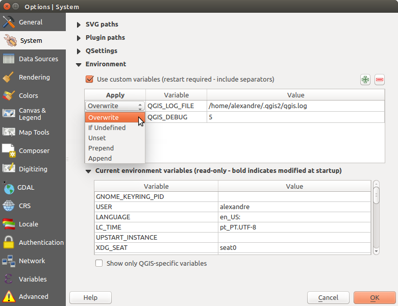
QGIS의 시스템 환경 변수
좌표계 설정
Default CRS for new projects
There is an option to automatically set new project’s CRS:
- Use CRS from first layer added: the CRS of the project
is turned to match the CRS of the first layer loaded into it
 Use a default CRS: a preselected CRS is applied by
default to any new project and is left unchanged when adding layers to the
project.
Use a default CRS: a preselected CRS is applied by
default to any new project and is left unchanged when adding layers to the
project.
The choice will be saved for use in subsequent QGIS sessions and in any case, the Coordinate Reference System of the project can still be overridden from the tab.
새 레이어를 위한 좌표계
여기에서 새 레이어를 생성하거나 좌표계가 정의되지 않은 레이어를 불러올 때 수행할 액션을 정의할 수 있습니다.
- Prompt for CRS
- Use project CRS
- Use a default CRS
기본 데이터 변환
In this group, you can control whether reprojecting layers to another CRS should be:
automatically processed using QGIS default transformations settings;
and/or more controlled by you with custom preferences such as:
- Ask for datum transformation if several are available
a predefined list of datum transformations to apply by default. See Datum Transformations for more details.
참고
For more information on how QGIS handles layers projection, please read the dedicated section at 투영 작업.
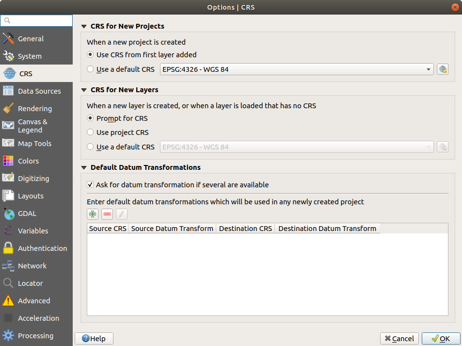
CRS Settings in QGIS
데이터소스 설정
피처 속성 및 테이블
- Open attribute table in a dock window
다른 응용 프로그램의 피처를 붙여넣을 경우 Copy features as 옵션으로 〈Plain text, no geometry〉, 〈Plain text, WKT geometry〉, 또는 〈GeoJSON〉 가운데 하나를 선택합니다.
Attribute table behavior
: 속성 테이블을 열 때의 필터를 설정합니다. 〈Show all features〉, 〈Show selected features〉 그리고 〈Show features visible on map〉 가운데 하나를 선택할 수 있습니다.Default view: 속성 테이블을 열 때의 뷰 모드를 정의합니다. 〈Remember last view〉, 〈Table view〉 또는 〈Form view〉 가운데 하나를 선택할 수 있습니다.
Attribute table row cache
 에서 속성 테이블 관련 작업을 빠르게 처리할 수 있도록 최근 속성 행을 몇 개나 행 캐시에 저장할지 설정할 수 있습니다. 속성 테이블을 닫으면 캐시를 삭제합니다.
Representation for NULL values 을 통해 NULL 값을 포함하는 데이터 항목을 위한 값을 정의할 수 있습니다.
팁
대용량 속성 테이블 열기를 향상시키기
대용량 레코드를 보유한 레이어를 작업하는 경우, 대화창이 레이어에 있는 모든 행을 요구하기 때문에 속성 테이블을 여는 데 시간이 많이 걸릴 수도 있습니다. Attribute table behavior 를 Show Features Visible On Map 으로 설정하면, QGIS가 테이블을 열 때 현재 맵 캔버스에 있는 피처만 요구하므로 데이터를 빨리 불러올 수 있습니다.
이 속성 테이블 인스턴스에 있는 데이터가 언제나 테이블을 열 당시의 캔버스 범위에 구속된다는 사실을 기억하십시오. 즉 해당 테이블에서 Show All Features 를 선택해도 새 피처들을 표시하지 않을 것이라는 뜻입니다. 하지만 속성 테이블에서 Show Features Visible On Map 옵션을 선택하고 캔버스 범위를 변경하면 화면에 표시된 피처 집합을 업데이트할 수 있습니다.
데이터소스 처리
Scan for valid items in the browser dock
을 통해 〈Check extension〉 과 〈Check file contents〉 가운데 하나를 선택할 수 있습니다.Scan for contents of compressed files (.zip) in browser dock
defines how detailed is the widget information at the bottom
of the Browser panel when querying such files. 〈No〉, 〈Basic scan〉 and 〈Full scan〉
are possible options.Prompt for raster sublayers when opening: 일부 래스터는 GDAL에서 하위 데이터셋이라고 부르는 하위 레이어를 지원합니다. netCDF 파일이 한 예입니다. netCDF 변수가 여러 개 있을 경우, GDAL은 모든 변수를 하위 데이터셋으로 간주합니다. 이 옵션은 하위 레이어를 보유한 파일을 열었을 때 하위 레이어를 어떻게 처리할지를 제어할 수 있게 해줍니다. 다음 가운데 하나를 선택할 수 있습니다:
‘Always’: (하위 레이어가 존재할 경우) 항상 물어봅니다.
‘If needed’: 레이어에 밴드는 없지만 하위 레이어는 있을 경우 물어봅니다.
‘Never’: 물어보지 않고, 아무것도 불러오지 않습니다.
‘Load all’: 물어보지 않지만, 모든 하위 레이어를 불러옵니다.
- Ignore shapefile encoding declaration 을 체크하면 shapefile에 인코딩 정보가 있더라도 QGIS가 무시할 것입니다.
- Add PostGIS layers with double click and select in
extended mode
- Add Oracle layers with double click and select in
extended mode
- Execute expressions on server-side if possible
- Evaluate default values defines whether default values
from database provider should be calculated when digitizing the new feature
(checked status) or when saving the changes.
숨겨진 탐색기 경로
This widget lists all the folders you chose to hide from the Browser panel. Removing a folder from the list will make it available in the Browser panel.
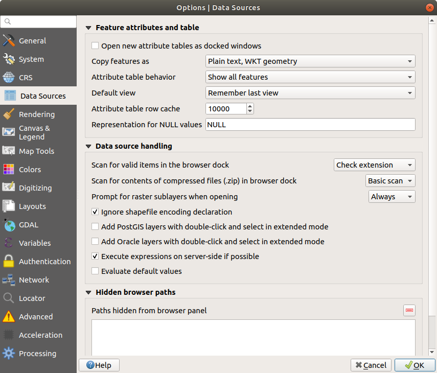
Data Sources Settings in QGIS
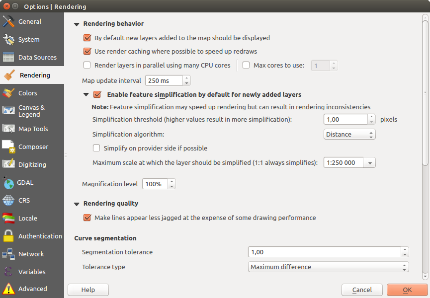
렌더링 설정
프로젝트 속성 대화창의 렌더링 탭
렌더링 습성
 By default new layers added to the map should be
displayed: unchecking this option can be handy when loading multiple layers
to avoid each new layer being rendered in the canvas and slow down the process
By default new layers added to the map should be
displayed: unchecking this option can be handy when loading multiple layers
to avoid each new layer being rendered in the canvas and slow down the process- Use render caching where possible to speed up redraws
- Render layers in parallel using many CPU cores
- Max cores to use
Map update interval (default to 250 ms)
- Enable feature simplification by default for newly added layers
Simplification threshold
Simplification algorithm: 이 옵션은 로컬에서 피처를 《실시간(on-the-fly)》 단순화시켜 도형 렌더링 속도를 향상시킵니다. 데이터 제공자에서 불러온 도형을 변경하지는 않습니다. 사용자가 피처 도형을 사용하는 표현식을 사용할 경우 (예를 들어 면적을 계산할 경우) 이 옵션은 중요합니다. 단순화된 도형이 아니라 원본 도형에 대해 계산이 이루어진다는 것을 보장하기 때문입니다. 이를 위해 QGIS는 〈Distance〉(기본값), 〈SnapToGrid〉 그리고 〈Visvalingam〉 세 가지 알고리즘을 제공합니다.
- Simplify on provider side if possible: PostGIS, Oracle 등의 제공자가 도형을 단순화하며, 로컬 단순화와는 달리 도형 기반 계산에 영향을 줄 수도 있습니다.
Maximum scale at which the layer should be simplified
 Magnification level (see the magnifier)
참고
일반 수준 설정 이외에도, 특정 레이어의 메뉴를 통해서도 피처 단순화를 설정할 수 있습니다.
렌더링 품질
- Make lines appear less jagged at the expense of some
drawing performance
곡선 선분
Segmentation tolerance: 이 설정은 원호(circular arc)를 렌더링하는 방식을 제어합니다. (연속된 꼭짓점 2개와 곡선 중점 사이의, 도 단위의) 최대 각도 또는 (두 꼭짓점의 선분과 곡선 사이의, 맵 단위의) 최대 거리 가운데 더 작은 쪽, 그리고 더 직선에 가까운 선분을 이용해서 렌더링할 것입니다.
Tolerance type: it can be Maximum angle or Maximum difference between approximation and curve.
래스터
RGB band selection 을 이용해서 적색, 녹색, 청색 밴드의 번호를 정의할 수 있습니다.
Contrast enhancement
Contrast enhancement options can be applied to Single band gray, Multi band color (byte/band) or Multi band color (>byte/band). For each, you can set:
the Algorithm to use, whose values can be 〈No stretch〉, 〈Stretch to MinMax〉, 〈Stretch and Clip to MinMax〉 or 〈Clip to MinMax〉
the Limits (minimum/maximum) to apply, with values such as 〈Cumulative pixel count cut〉, 〈Minimum/Maximum〉, 〈Mean +/- standard deviation〉.
For rasters rendering, you can also define the following options:
Cumulative pixel count cut limits
Standard deviation multiplier
디버그
- Map canvas refresh to debug rendering duration in
the Log Messages panel.
캔버스 및 범례 설정
캔버스 및 범례 설정
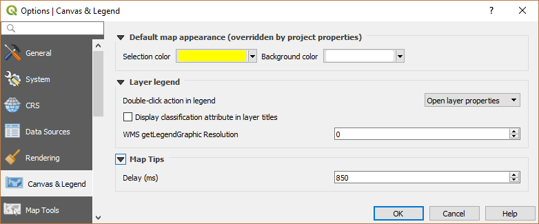
These properties let you set:
the Default map appearance (overridden by project properties): the Selection color and Background color.
Layer legend interaction:
Double click action in legend
: 더블 클릭을 하면 〈Open layer properties’를 할지 〈Open attribute table’을 할지 또는’Open layer styling dock’을 할지 선택할 수 있습니다.- Display classification attribute names in the Layers
panel, e.g. when applying a categorized or rule-based renderer
(see Symbology Properties for more information).
the WMS getLegendGraphic Resolution
the Delay in milliseconds of layers map tips display
맵 도구 설정
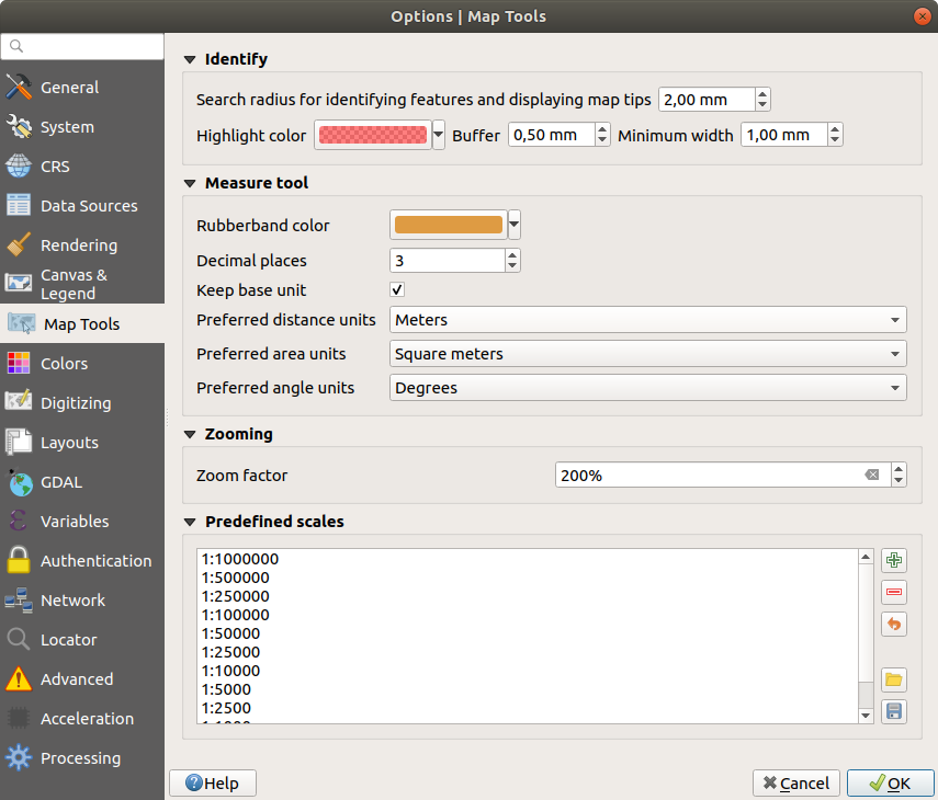
이 탭은 식별 도구 의 습성과 관련된 여러 옵션을 제공합니다.
Search radius for identifying features and displaying map tips is a tolerance distance within which the identify tool will depict results as long as you click within this tolerance.
Highlight color 에서 식별된 피처를 어떤 색상으로 강조할지 선택할 수 있습니다.
Buffer 에서 식별 강조 윤곽선을 어느 정도의 버퍼 거리로 렌더링할지 설정합니다.
Minimum width 에서 강조된 객체의 윤곽선을 얼마나 굵게 할지 설정합니다.
측정 도구
측정 도구 용 Rubberband color 를 정의합니다.
Decimal places 를 정의합니다.
- Keep base unit 을 체크하면 자동적으로 큰 숫자로 (예를 들어 미터를 킬로미터로) 변환하는 걸 막아줍니다.
Preferred distance units
에서 〈미터〉, 〈킬로미터〉, 〈피트〉, 〈야드〉, 〈마일〉, 〈해리(Nautical Miles)〉, 〈도(Degrees)〉 또는 〈맵 단위〉 가운데 하나를 선택합니다.Preferred area units
(〈Square meters〉, 〈Square
kilometers〉, 〈Square feet〉, 〈Square yards〉, 〈Square miles〉, 〈Hectares〉,
〈Acres〉, 〈Square nautical miles〉, 〈Square degrees〉 or 〈Map Units〉)Preferred angle units
에서 〈도〉, 〈라디안〉, 그레이드(Gon/gradians)〉, 〈Minutes of arc〉, 〈Seconds of arc〉 또는 〈Turns/revolutions〉 가운데 하나를 선택합니다.
이동 및 확대/축소
확대/축소 도구 또는 마우스 휠 용 Zoom factor 를 정의합니다.
사전 정의 축척
여기에서 사전 정의된 축척 목록을 볼 수 있습니다.  및
및  버튼으로 사용자 지정 축척을 추가하거나 제거할 수 있습니다. 또 축척을
 .XML 파일 포맷으로 내보내거나 불러올 수 있습니다. 사용자 변경 사항을 제거하고 사전 정의 목록으로 초기화할 수 있다는 사실을 기억하십시오.
Map tools Settings in QGIS
색상 설정
This menu allows you to create or update palettes of colors used throughout the application in the color selector widget. You can choose from:
Recent colors showing recently used colors
Standard colors, the default palette of colors
Project colors, a set of colors specific to the current project (see Default Styles Properties for more details)
New layer colors, a set of colors to use by default when new layers are added to QGIS
or custom palette(s) you can create or import using the … button next to the palette combobox.
By default, Recent colors, Standard colors and Project colors palettes can not be removed and are set to appear in the color button drop-down. Custom palettes can also be added to this widget thanks to the Show in Color Buttons option.
For any of the palettes, you can manage the list of colors using the set of tools next to the frame, ie:
- Add or Remove color
 Copy or
  Paste color
 Import or
  Export the set of colors
from/to
Export the set of colors
from/to .gplfile.
Double-click a color in the list to tweak or replace it in the Color Selector dialog. You can also rename it by double-clicking in the Label column.
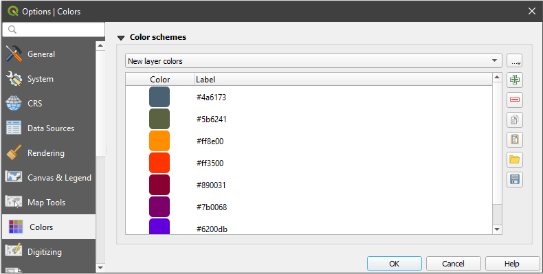
색상 설정
디지타이즈 작업 설정
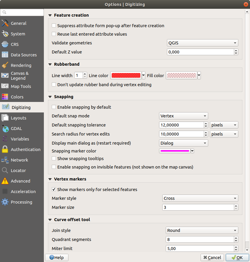
이 탭에서 벡터 레이어 편집 시 (속성 및 도형) 이용할 수 있는 일반 설정의 환경을 설정할 수 있습니다.
피처 생성
- Suppress attribute form pop-up after feature creation:
this choice can be overridden in each layer properties dialog.
- Reuse last entered attribute values.
Validate geometries. 많은 노드를 보유한 복잡한 라인 및 폴리곤을 편집하는 작업 시 렌더링이 아주 느려질 수 있습니다. QGIS의 기본 유효성 확인 과정에 시간이 오래 걸릴 수 있기 때문입니다. GEOS 도형 유효성 확인을 (GEOS 3.3 버전부터 사용 가능) 활성화하거나, 도형 유효성 확인 과정을 비활성화해서 렌더링 속도를 높일 수 있습니다. GEOS 도형 유효성 확인은 훨씬 빠르지만, 첫 도형 문제점만 표시한다는 단점이 있습니다.
Default Z value to use when creating new 3D features.
고무줄
Define Rubberband Line width, Line color and Fill color.
Don’t update rubberband during vertex editing.
스냅
- Enable snapping by default activates snapping when
a project is opened
Define Default snap mode
(〈Vertex〉, 〈Vertex and segment〉,
〈Segment〉)Default snapping tolerance 를 정의합니다. 맵 단위 또는 픽셀 개수로 설정할 수 있습니다.
Search radius for vertex edits 을 정의합니다. 맵 단위 또는 픽셀 개수로 설정할 수 있습니다.
Display main dialog as (restart required): set whether the Advanced Snapping dialog should be shown as 〈Dialog〉 or 〈Dock〉.
Snapping marker color
- Show snapping tooltips such as name of the layer whose
feature you are about to snap. Helpful when multiple features overlap.
- Enable snapping on invisible features
꼭짓점 마커
- Show markers only for selected features
꼭짓점 Marker style
을 정의합니다. 〈Cross〉 (default), 〈Semi transparent circle〉 또는 〈None〉 가운데 하나를 선택할 수 있습니다.꼭짓점 Marker size 를 정의합니다.
곡선 오프셋 도구
다음 세 가지 옵션은 고급 디지타이즈 작업 의  Offset Curve 에서 쓰입니다. 다양한 설정을 통해, 라인 오프셋의 형태를 변경할 수 있습니다. GEOS 3.3 버전부터 이 옵션들을 사용할 수 있습니다.
Join style 로 〈Round〉, 〈Mitre〉 또는 〈Bevel〉 가운데 하나를 선택할 수 있습니다.
Quadrant segments
Miter limit
Digitizing Settings in QGIS
Layouts Settings
조판 기본값
You can define the Default font used within the print layout.
그리드 모양
Grid style
에서 〈Solid〉, 〈Dots〉, 〈Crosses〉 가운데 하나를 선택합니다.Grid color 를 정의합니다.
그리드 및 가이드 기본값
Grid spacing
을 정의합니다.Define the Grid offset
for X and YSnap tolerance
를 정의합니다.
Layout Paths
Define Path(s) to search for extra print templates: a list of folders with custom layout templates to use while creating new one.
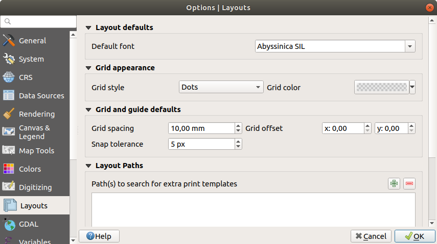
Layouts Settings in QGIS
GDAL 설정
GDAL is a data exchange library for vector and raster files. It provides drivers to read and or write data in different formats. The GDAL tab currently exposes the drivers for raster formats with their capabilities.
GDAL driver options
This frame provides ways to customize the behavior of drivers that support read and write access:
Edit create options: allows you to edit or add different profiles of file transformation, i.e. a set of predefined combinations of parameters (type and level of compression, blocks size, overview, colorimetry, alpha…) to use when outputting raster files. The parameters depend on the driver.
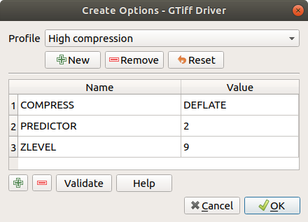
Sample of create options profile (for GeoTiff)
The upper part of the dialog lists the current profile(s) and allows you to add new ones or remove any of them. You can also reset the profile to its default parameters if you have changed them. Some drivers (eg, GeoTiff) have some sample of profiles you can work with.
At the bottom of the dialog:
The
button lets you add rows to fill with the parameter name and valueThe
button deletes the selected parameterClick the Validate button to check that the creation options entered for the given format are valid
Use the Help button to find the parameters to use, or refer to the GDAL raster drivers documentation.
Edit Pyramids Options
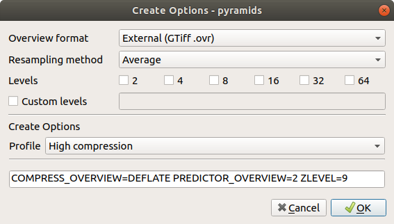
Sample of Pyramids profile
GDAL drivers
In this frame, you can define which GDAL driver is to use to read and/or write files, as in some cases more than one GDAL driver is available.
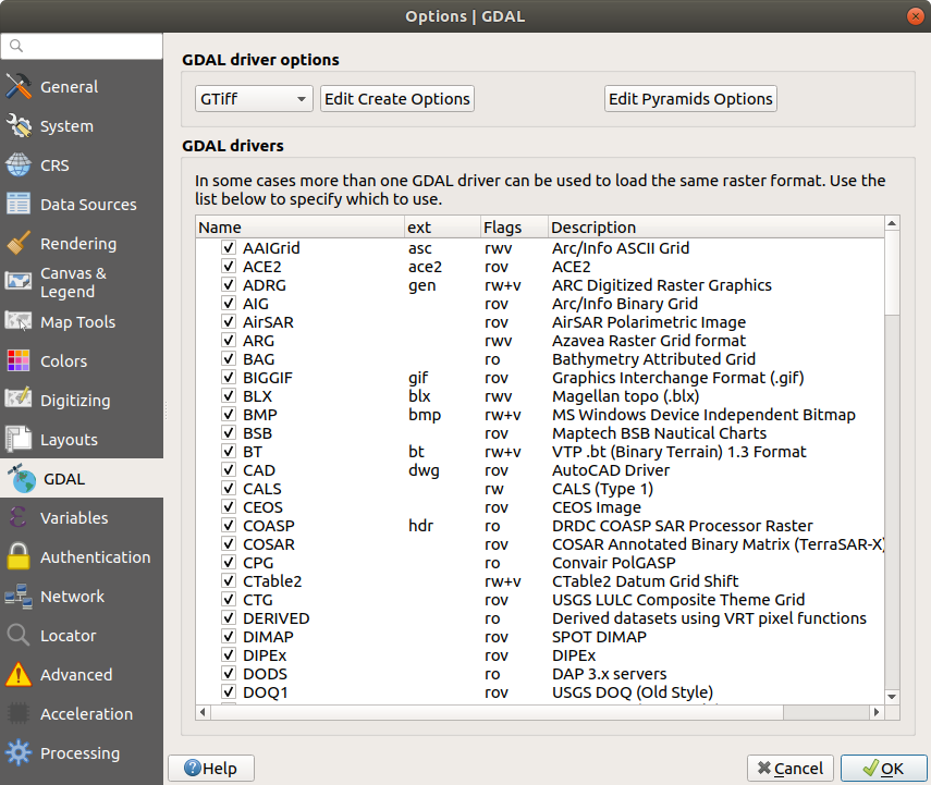
GDAL Settings in QGIS
팁
Double-click a driver that allows read and write access (rw+(v))
opens the Edit Create options dialog for
customization.
변수 설정
Variables 탭은 전체 수준에서 쓸 수 있는 모든 변수들의 목록을 표시합니다.
또한 사용자가 전체 수준 변수를 관리할 수도 있습니다. 버튼을 클릭해서 새 사용자 지정 전체 수준 변수를 추가합니다. 마찬가지로, 목록에서 사용자 지정 전체 수준 변수를 선택한 다음 버튼을 클릭해서 제거합니다.
Storing values in Variables 에서 변수에 대한 더 자세한 정보를 살펴볼 수 있습니다.
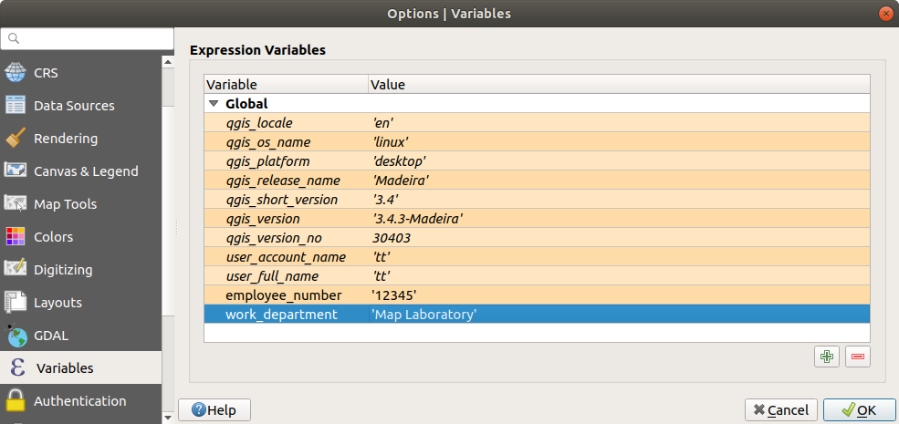
Variables Settings in QGIS
인증 설정
Authentication 탭에서 인증 환경을 설정하고 PKI 인증서를 관리할 수 있습니다. 더 자세한 내용은 인증 시스템 을 참조하세요.
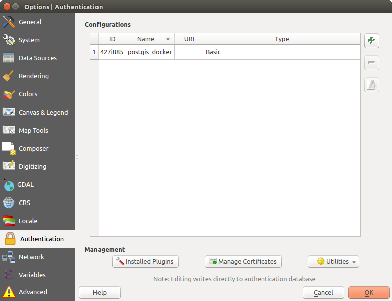
Authentication Settings in QGIS
Network Settings
일반
WMS search address 를 정의합니다. 기본값은
http://geopole.org/wms/search?search=\%1\&type=rss입니다.Timeout for network requests (ms) 를 정의합니다. 기본값은 60,000입니다.
Default expiration period for WMS Capabilities (hours) 를 정의합니다. 기본값은 24입니다.
Default expiration period for WMSC/WMTS tiles (hours) 를 정의합니다. 기본값은 24입니다.
Max retry in case of tile or feature request errors 를 정의합니다.
User-Agent 를 정의합니다.
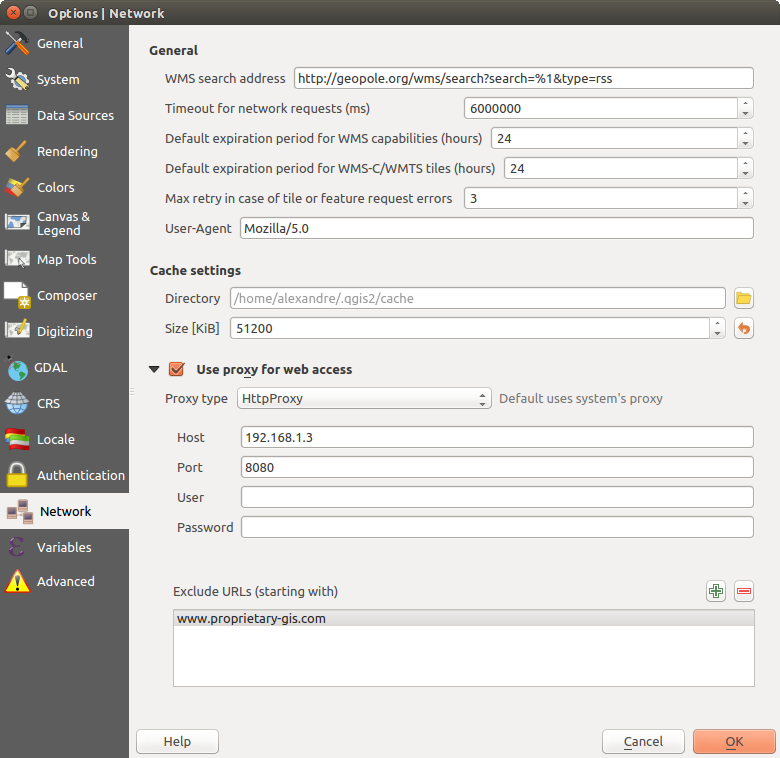
QGIS의 프록시 설정
캐시 설정
Defines the Directory and a Size for the cache. Also offers tools to automatically clear the connection authentication cache on SSL errors (recommended).
Proxy for web access
- Use proxy for web access
Set the Proxy type
according to your needs and
define 〈Host〉 and 〈Port〉. Available proxy types are:: Proxy is determined based on system’s proxy
: 모든 종류의 연결에 쓸 수 있는 일반 프록시입니다. TCP, UDP, 지정 포트(들어오는 연결) 그리고 인증을 지원합니다.
: 《CONNECT》 명령어로 시행되며, 나가는 TCP 연결만 지원하고, 인증을 지원합니다.
: 통상적인 HTTP 명령어로 시행되며, HTTP 요청이라는 맥락 안에서만 유용합니다.
: FTP 프록시를 이용해서 시행되며, FTP 요청이라는 맥락 안에서만 유용합니다.
Credentials of proxy are set using the authentication widget.
프록시 설정 아래에 있는 텍스트 상자에 제외시킬 URL을 추가할 수 있습니다. (QGIS의 프록시 설정 그림 참조)
If you need more detailed information about the different proxy settings, please refer to the manual of the underlying QT library documentation at https://doc.qt.io/qt-5.9/qnetworkproxy.html#ProxyType-enum
팁
프록시 사용
프록시 사용은 때로 까다로울 수 있습니다. 앞에서 설명한 프록시 유형들을 〈시행착오’를 거쳐 가며 사용자의 환경에서 어떤 유형이 작동하는지 확인하는 편이 좋습니다.
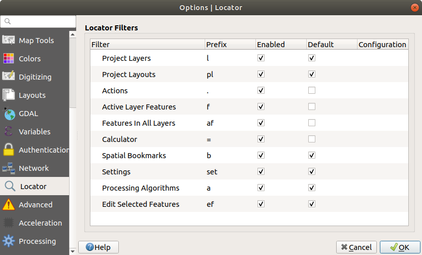
Locator Settings
 The Locator tab allows to configure the Locator bar, a
quick search widget available on the status bar that helps you perform searches
anywhere in the application. It provides some default filters (with prefix) to use:
The Locator tab allows to configure the Locator bar, a
quick search widget available on the status bar that helps you perform searches
anywhere in the application. It provides some default filters (with prefix) to use:
Project layers (
l): finds and selects a layer in the Layers panel.Project layouts (
pl): finds and opens a print layout.Actions (
.): finds and executes a QGIS action; actions can be any tool or menu in QGIS, opening a panel…Active layer features (
f): searches for matching attributes in any field from the current active layer and zooms to the selected feature.Features in all layers (
af): searches for matching attributes in the display name of each searchable layers and zooms to the selected feature.Calculator (
=): allows evaluation of any QGIS expression and, if valid, gives an option to copy the result to the clipboard.Spatial bookmarks (
b): finds and zooms to the bookmark extent.Settings (
set): browses and opens project and application-wide properties dialogs.Processing (
a): searches and opens a Processing algorithm dialog.Edit selected features (
ef): gives quick access and runs a compatible modify-in-place Processing algorithm on the active layer.
For each filter, you can customize the filter, set whether it is enabled by default or not. The set of default locator filters can be extended by plugins, eg for OSM nominatim searches, direct database searching, layer catalog searches.
The locator search bar can be activated pressing Ctrl+K. Type your text
to perform a search. By default, results are returned for all enabled locator
filters but you can limit the search to a certain filter by prefixing your
text with the locator filter prefix, ie. typing l cad will return only the
layers whose name contains cad. Click on the result to execute the
corresponding action, depending on the type of item.
Searching is handled using threads, so that results always become available as quickly as possible, regardless of whether any slow search filters may be installed. They also appear as soon as each result is encountered by each filter, which means that e.g. a file search filter will show results one by one as the file tree is scanned. This ensures that the UI is always responsive even if a very slow search filter is present (e.g. one which uses an online service).
팁
Quick access to the locator’s configurations
Click on the icon inside the locator widget on the status bar to
display the list of filters you can use and a Configure entry that
opens the Locator tab of the menu.
Locator Settings in QGIS
고급 설정
사용자 OS 별로, QGIS 관련 모든 설정(UI, 도구, 데이터 제공자, 기본값, 플러그인 옵션 등등)을 다음 위치에 저장합니다:

$HOME/.config/QGIS/QGIS2.conf텍스트 파일에 설정을 저장합니다.
$HOME/Library/Preferences/org.qgis.qgis.plist속성 목록 파일에 설정을 저장합니다.
HKEY\CURRENT_USER\Software\QGIS\qgis레지스트리에 설정을 저장합니다.
OS에 상관없이, Advanced 탭의 Advanced Settings Editor 한 곳에서 이 설정들을 관리할 수 있습니다. 사용자 주의 사항을 확인하면 위젯에 모든 QGIS 설정들의 트리가 표시되는데, 사용자가 직접 편집할 수 있습니다.
경고
고급 탭 설정을 무턱대고 이용하지 말 것
이 대화창에서 항목을 수정할 때 조심해야 합니다. 변경 사항이 자동적으로 적용되기 때문입니다. 자세한 내용을 모른 채 설정을 수정하면 사용자의 QGIS 설치본이 여러 방식으로 고장날 수 있습니다.
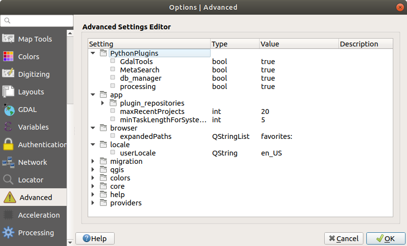
Advanced Settings tab in QGIS
Processing Settings
The  Processing tab provides you with general settings
of tools and data providers that are used in the QGIS Processing framework.
More information at QGIS 공간 처리 프레임워크.
Processing tab provides you with general settings
of tools and data providers that are used in the QGIS Processing framework.
More information at QGIS 공간 처리 프레임워크.
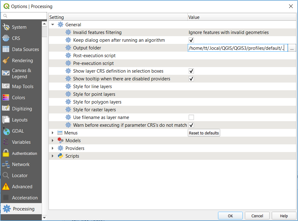
Processing Settings tab in QGIS
Working with User Profiles
The menu provides functions to set and access user profiles. A user profile is a unified application configuration that allows to store in a single folder:
all the global settings, including locale, projections, authentication settings, color palettes, shortcuts…
GUI configurations and customization
installed plugins and their configurations
project templates and history of saved project with their image preview
processing settings, logs, scripts, models.
By default, a QGIS installation contains a single user profile named default.
But you can create as many user profiles as you want:
Click the New profile… entry.
You’ll be prompted to provide a profile name, creating a folder of the same name under
~/<UserProfiles>/where:~represents the HOME directory, which on Windows is usually
something like C:\Users\(user).and
<UserProfiles>represents the main profiles folder, i.e.:-
.local/share/QGIS/QGIS3/profiles/ -
AppData\Roaming\QGIS\QGIS3\profiles\ -
Library/Application Support/QGIS/QGIS3/profiles/
The user profile folder can be opened from within QGIS using the Open Active Profile Folder.
A new instance of QGIS is started, using a clean configuration. You can then set your custom configurations.
As each user profile contains isolated settings, plugins and history they can be great for different workflows, demos, users of the same machine, or testing settings, etc. And you can switch from one to the other by selecting them in the menu. You can also run QGIS with a specific user profile from the command line.
Unless changed, the profile of the last closed QGIS session will be used in the following QGIS sessions.
팁
Run QGIS under a new user profile to check for bug persistence
When you encounter weird behavior with some functions in QGIS, create a new user profile and run the commands again. Sometimes, bugs are related to some leftovers in the current user profile and creating a new one may fix them as it restarts QGIS with the new (clean) profile.
프로젝트 속성
In the properties window for the project under , you can set project-specific options. The project-specific options overwrite their equivalent in the Options dialog described above.
General Properties
In the General tab, the General settings let you:
see the location of the project file
set the folder for the project home (available in the
Project Homeitem in the browser). The path can be relative to the folder of the project file (type it in) or absolute. The project home can be used for storing data and other content that is useful for the project.프로젝트 파일 경로 옆에 프로젝트 제목을 부여할 수 있고
피처 선택 시 피처에 적용할 색상을 선택할 수 있고
맵 캔버스에 적용할 배경색을 선택할 수 있으며
프로젝트 내부의 레이어를 가리키는 경로를 절대 경로(전체 경로)로 저장할지 프로젝트 파일 위치에 상대적인 상대 경로로 저장할지 설정할 수 있습니다. 레이어 및 프로젝트 파일이 이동 또는 공유될 가능성이 있거나, 다른 플랫폼을 이용하는 컴퓨터에서 프로젝트에 접근하는 경우, 상대 경로가 더 적합할 수도 있습니다.
프로젝트를 맵 타일로 렌더링할 때 오류(artifact)를 회피하도록 선택할 수 있습니다. 이 옵션을 체크하면 성능이 저하될 수도 있다는 점을 주의하십시오.
Calculating areas and distances is a common need in GIS. However, these values are really tied to the underlying projection settings. The Measurements frame lets you control these parameters. You can indeed choose:
the Ellipsoid, on which distance and area calculations are entirely based; it can be:
None/Planimetric: returned values are in this case cartesian measurements.
a Custom one: you’ll need to set values of the semi-major and semi-minor axes.
or an existing one from a predefined list (Clarke 1866, Clarke 1880 IGN, New International 1967, WGS 84…).
길이 및 둘레에 대한 units for distance measurements 및 면적에 대한 units for area measurements 를 설정하면 현재 프로젝트에서 QGIS 옵션에 설정된 기본 단위를 무시하게 만들며, 다음에 쓰입니다:
속성 테이블 필드 업데이트 바
필드 계산기 계산
식별 도구에서 파생되는 길이, 둘레 및 면적 값
측정 대화창에 표시되는 기본 단위
The Coordinate display allows you to choose and customize the format of units to use to display the mouse coordinate in the status bar and the derived coordinates shown via the identify tool.
Finally, you can set a Project predefined scales list, which overrides the global predefined scales.
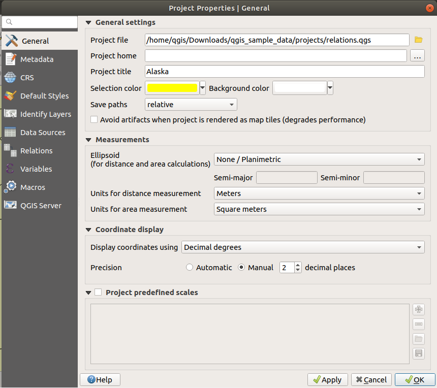
프로젝트 속성 대화창의 일반 탭
Metadata Properties
The Metadata tab allows detailed metadata to be defined, including (among the others): author, creation date, language, abstracts, categories, keywords, contact details, links, history. There is also a validation functionality that checks if specific fields were filled, anyway this is not enforced. See vector layer metadata properties for some details.
CRS Properties
The  CRS tab helps you set the coordinate reference system
to use in this project. It can be:
CRS tab helps you set the coordinate reference system
to use in this project. It can be:
- No projection (or unknown/non-Earth projection):
this setting can be used to guess a layer CRS or when using QGIS for non
earth uses like role-playing game maps, building mapping or microscopic stuff.
In this case:
No reprojection is done while rendering the layers: features are just drawn using their raw coordinates.
The ellipsoid is locked out and forced to
None/Planimetric.The distance and area units, and the coordinate display are locked out and forced to 《unknown units》; all measurements are done in unknown map units, and no conversion is possible.
or an existing coordinate reference system that can be geographic, projected or user-defined. A preview of the CRS extent on earth is displayed to help you select the appropriate one. Layers added to the project are on-the-fly translated to this CRS in order to overlay them regardless their original CRS. Use of units, ellipsoid setting are available and make sense and you can perform calculations accordingly.
The CRS tab also helps you control the layers reprojection
settings by configuring the datum transformation preferences to apply in the
current project. As usual, these override any corresponding global settings.
See Datum Transformations for more details.
Default Styles Properties
The Default Styles tab lets you control how new layers will be
drawn in the project when they do not have an existing .qml style
defined. You can:
Set default symbols (Marker, Line, Fill) to apply depending on the layer geometry type as well as a default Color Ramp
Apply a default Opacity to new layers
- Assign random colors to symbols, modifying the symbols
fill colors, hence avoiding same rendering for all layers.
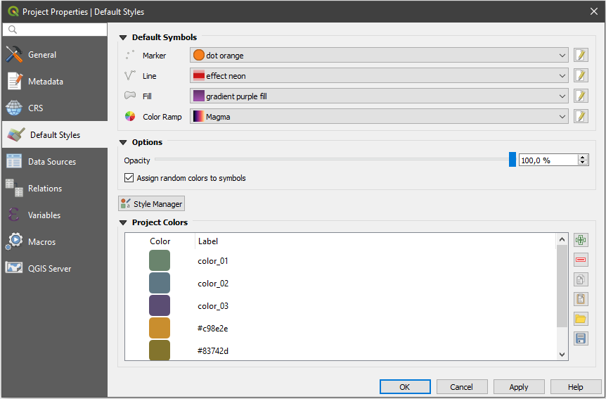
Default Styles tab
Using the Style Manager button, you can also quickly
access the Style Manager dialog and configure
symbols and color ramps.
There is also an additional section where you can define specific colors for the running project. Like the global colors, you can:
- Add or Remove color
- Copy or Paste color
- Import or Export the set of colors
from/to
.gplfile.
Double-click a color in the list to tweak or replace it in the Color Selector dialog. You can also rename it by double-clicking in the Label column.
These colors are identified as Project colors and listed as part of color widgets.
팁
Use project colors to quickly assign and update color widgets
Project colors can be refered to using their label and the color widgets they are used in are bound to them. This means that instead of repeatedly setting the same color for many properties and, to avoid a cumbersome update you can:
Define the color as a project color
Apply it using the
project_color('color_label')expression in color data defined override widgetUpdate the color once in a Project colors list
And the change is reflected EVERYWHERE.
Data Sources Properties
Data Sources 탭에서 다음 설정을 할 수 있습니다:
- Automatically create transaction groups where possible:
When this mode is turned on, all
(postgres) layers from the same database are synchronised in their edit state,
i.e. when one layer is put into edit state, all are, when one layer is committed
or one layer is rolled back, so are the others. Also, instead of buffering edit
changes locally, they are directly sent to a transaction in the database which
gets committed when the user clicks save layer.
Note that you can (de)activate this option only if no layer is being edited
in the project.
- Evaluate default values on provider side: When adding
new features in a PostgreSQL table, fields with default value constraint are
evaluated and populated at the form opening, and not at the commit moment.
This means that instead of an expression like
nextval('serial'), the field in the Add Feature form will display expected value (e.g.,25). - Trust project when data source has no metadata:
To speed up project loading by skipping data checks. Useful in QGIS Server context
or in projects with huge database views/materialized views. The extent of layers
will be read from the QGIS project file (instead of data sources) and when
using the PostgreSQL provider the primary key unicity will not be
checked for views and materialized views.
Configure the Layers Capabilities, i.e.:
Set (or disable) which layers are
identifiable, i.e. will respond to the identify tool. By default, layers are set queryable.Set whether a layer should appear as
read-only, meaning that it can not be edited by the user, regardless of the data provider’s capabilities. Although this is a weak protection, it remains a quick and handy configuration to avoid end-users modifying data when working with file-based layers.Define which layers are
searchable, i.e. could be queried using the locator widget. By default, layers are set searchable.Define which layers are defined as
required. Checked layers in this list are protected from inadvertent removal from the project.
The Layers Capabilities table provides some convenient tools to:
Select multiple cells and press Toggle Selection to have them change their checkbox state;
- Show spatial layers only, filtering out non-spatial
layers from the layers list;
- Filter layers… and quickly find a particular layer to
configure.
Relations Properties
Relations 탭은 일대다(1:n) 관계를 정의하는 데 쓰입니다. 프로젝트 속성 대화창에서 이 관계를 정의합니다. 어떤 레이어에 관계가 존재하는 경우, 양식 뷰에 있는 새 사용자 인터페이스 요소가 (예를 들어 피처를 식별하고 그 양식을 열 때) 관련 요소들의 목록을 표시할 것입니다. 이렇게 되면, 예를 들어 어떤 파이프라인 또는 도로 구간의 점검 이력을 보여줄 수 있는 강력한 방법이 생기는 겁니다. 일대다 또는 다대다 관계 생성 에서 일대다 관계에 대한 더 자세한 내용을 찾아볼 수 있습니다.
Variables Properties
Variables 탭은 (모든 전체 수준 변수를 포함하는) 프로젝트 수준에서 사용할 수 있는 모든 변수 목록을 표시합니다. 게다가, 사용자가 프로젝트 수준 변수를 관리할 수도 있습니다. 버튼을 클릭해서 새 사용자 지정 프로젝트 수준 변수를 추가합니다. 마찬가지로, 목록에서 사용자 지정 프로젝트 수준 변수를 선택한 다음 버튼을 클릭해서 제거합니다. 일반 도구 장의 ref:general_tools_variables 절에서 변수 사용법에 대한 자세한 정보를 살펴볼 수 있습니다.
Macros Properties
Macros 탭은 프로젝트를 위한 파이썬 매크로를 편집하는 데 쓰입니다. 현재, openProject(), saveProject() 그리고 closeProject() 세 가지 매크로만 사용할 수 있습니다.
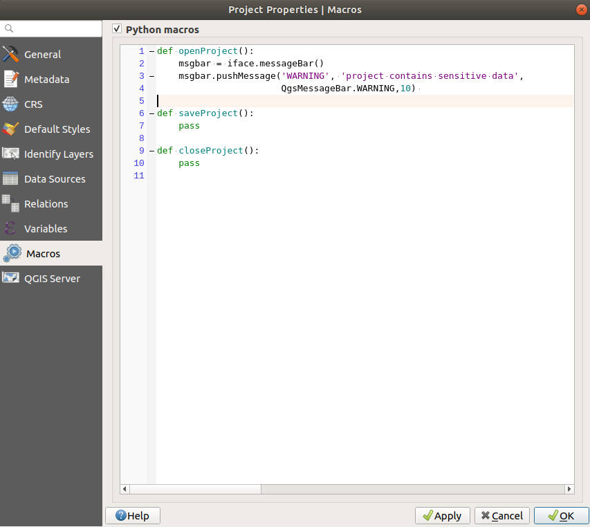
QGIS의 매크로 설정
QGIS Server Properties
The tab QGIS Server allows you to configure your project in order to publish it online. Here you can define information about the QGIS Server WMS and WFS capabilities, extent and CRS restrictions. More information available in section Configure your project and subsequent.
사용자 지정
사용자 지정 작업 대화창을 통해 QGIS 사용자 인터페이스의 거의 모든 요소를 (비)활성화할 수 있습니다. 최종 사용자가 필요로 하는 아이콘, 메뉴 또는 패널만 있는 〈가벼운〉 QGIS 버전을 제공하고자 할 때 매우 유용합니다.
참고
사용자 변경 사항을 적용하려면 QGIS를 재시작해야 합니다.
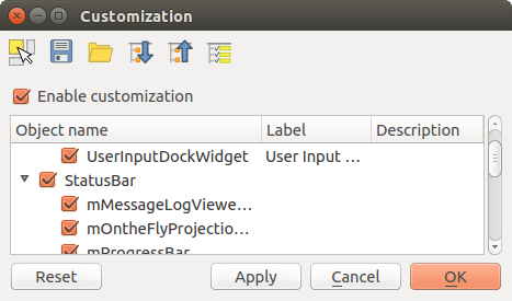
사용자 지정 작업 대화창
Enable customization 체크박스를 체크하는 일이 QGIS 사용자 지정 작업의 첫 번째 단계입니다. 툴바 및 위젯 패널을 활성화하는데, 이 패널에서 몇몇 GUI 항목을 체크 해제해서 쓸 수 없게 만들 수 있습니다.
환경을 설정할 수 있는 항목은 다음과 같습니다:
메뉴 또는 메뉴 바 에 있는 몇몇 하위 메뉴
패널 전체 (패널 및 툴바 참조)
상태 바 에서 설명한 상태 바 또는 상태 바의 몇몇 항목들
툴바 전체 또는 툴바의 일부 아이콘들
라벨, 버튼, 콤보박스 등 QGIS의 모든 대화창의 모든 위젯
 Switch to catching widgets in main application 을 통해, QGIS 인터페이스에서 사용자가 숨기고 싶은 항목을 클릭할 수 있습니다. 그러면 QGIS가 사용자 지정 작업 대화창에서 대응 항목을 자동적으로 체크 해제할 것입니다.
Once you setup your configuration, click Apply or OK to validate your changes. This configuration becomes the one used by default by QGIS at the next startup.
Save To File 버튼을 클릭하면 변경 사항들을 .ini 파일로도 저장할 수 있습니다. 사용자 여러 명이 QGIS 인터페이스를 공유할 수 있는 간편한 방법입니다. 다른 컴퓨터에서 이 .ini 파일을 불러오려면 Load from File 만 클릭하면 됩니다. 또 명령어 도구 를 실행해서 서로 다른 사용 목적을 위한 다양한 설정을 저장할 수도 있습니다.
팁
사전 정의된 QGIS를 손쉽게 복구
다음 방법들 가운데 하나를 통해 초기 QGIS GUI 환경 설정을 복구할 수 있습니다:
사용자 지정 작업 대화창에서
Enable customization 을 체크 해제하거나  Check All 버튼을 클릭합니다.
pressing the Reset button in the QSettings frame under menu, System tab
명령 프롬프트에서 QGIS를 다음 명령어
qgis --nocustomization로 실행합니다.메뉴의 Advanced 탭에 있는 변수의 값을
false로 설정합니다. (경고 참조)
대부분의 경우, 이 변경 사항을 적용하려면 QGIS를 재시작해야 합니다.
키보드 단축키
QGIS provides default keyboard shortcuts for many features. You can find them in
section 메뉴 바. Additionally, the menu option
allows you to change the default keyboard shortcuts and add new
ones to QGIS features.
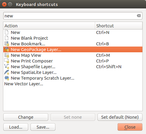
단축키 옵션 정의
Configuration is very simple. Use the search box at the top of the dialog to find a particular action, select it from the list and click on :
Change and press the new combination you want to assign as new shortcut
Set None to clear any assigned shortcut
or Set Default to backup the shortcut to its original and default value.
Proceed as above for any other tools you wish to customize. Once you have
finished your configuration, simply Close the dialog to have your changes
applied. You can also Save the changes as an .XML file
and Load them into another QGIS installation.
Running QGIS with advanced settings
Command line and environment variables
We’ve seen that launching QGIS is done as for any
application on your OS.
QGIS provides command line options for more advanced use cases (in some cases
you can use an environment variable instead of the command line option).
To get a list of the options, enter qgis --help on the command line, which
returns:
QGIS is a user friendly Open Source Geographic Information System.
Usage: /usr/bin/qgis.bin [OPTION] [FILE]
  OPTION:
        [--version]     display version information and exit
        [--snapshot filename]   emit snapshot of loaded datasets to given file
        [--width width] width of snapshot to emit
        [--height height]       height of snapshot to emit
        [--lang language]       use language for interface text (changes existing override)
        [--project projectfile] load the given QGIS project
        [--extent xmin,ymin,xmax,ymax]  set initial map extent
        [--nologo]      hide splash screen
        [--noversioncheck]      don't check for new version of QGIS at startup
        [--noplugins]   don't restore plugins on startup
        [--nocustomization]     don't apply GUI customization
        [--customizationfile path]      use the given ini file as GUI customization
        [--globalsettingsfile path]     use the given ini file as Global Settings (defaults)
        [--authdbdirectory path] use the given directory for authentication database
        [--code path]   run the given python file on load
        [--defaultui]   start by resetting user ui settings to default
        [--hide-browser]        hide the browser widget
        [--dxf-export filename.dxf]     emit dxf output of loaded datasets to given file
        [--dxf-extent xmin,ymin,xmax,ymax]      set extent to export to dxf
        [--dxf-symbology-mode none|symbollayer|feature] symbology mode for dxf output
        [--dxf-scale-denom scale]       scale for dxf output
        [--dxf-encoding encoding]       encoding to use for dxf output
        [--dxf-map-theme maptheme]      map theme to use for dxf output
        [--take-screenshots output_path]        take screen shots for the user documentation
        [--screenshots-categories categories]   specify the categories of screenshot to be used (see QgsAppScreenShots::Categories).
        [--profile name]        load a named profile from the user's profiles folder.
        [--profiles-path path]  path to store user profile folders. Will create profiles inside a {path}\profiles folder
        [--version-migration]   force the settings migration from older version if found
        [--openclprogramfolder]         path to the folder containing the sources for OpenCL programs.
        [--help]                this text
        [--]            treat all following arguments as FILEs

  FILE:
    Files specified on the command line can include rasters,
    vectors, and QGIS project files (.qgs and .qgz):
     1. Rasters - supported formats include GeoTiff, DEM
        and others supported by GDAL
     2. Vectors - supported formats include ESRI Shapefiles
        and others supported by OGR and PostgreSQL layers using
        the PostGIS extension
팁
Example Using command line arguments
You can start QGIS by specifying one or more data files on the command
line. For example, assuming you are in the qgis_sample_data
directory, you could start QGIS with a vector layer and a raster file
set to load on startup using the following command:
qgis ./raster/landcover.img ./gml/lakes.gml
--version
This option returns QGIS version information.
--snapshot
This option allows you to create a snapshot in PNG format from the current view. This comes in handy when you have many projects and want to generate snapshots from your data, or when you need to create snapshots of the same project with updated data.
Currently, it generates a PNG file with 800x600 pixels. The size can be adjusted
using the --width and --height arguments. The filename can
be added after --snapshot. For example:
qgis --snapshot my_image.png --width 1000 --height 600 --project my_project.qgs
--width
This option returns the width of the snapshot to be emitted (used with --snapshot).
--height
This option returns the height of the snapshot to be emitted (used with --snapshot).
--lang
Based on your locale, QGIS selects the correct localization. If you would like
to change your language, you can specify a language code. For example,
qgis --lang it starts QGIS in Italian localization.
--project
Starting QGIS with an existing project file is also possible. Just add the
command line option --project followed by your project name and QGIS will
open with all layers in the given file loaded.
--extent
To start with a specific map extent use this option. You need to add the bounding box of your extent in the following order separated by a comma:
--extent xmin,ymin,xmax,ymax
This option probably makes more sense when paired with the --project option
to open a specific project at the desired extent.
--nologo
This option hides the splash screen when you start QGIS.
--noversioncheck
Skip searching for a new version of QGIS at startup.
--noplugins
If you have trouble at start-up with plugins, you can avoid loading them at start-up with this option. They will still be available from the Plugins Manager afterwards.
--nocustomization
Using this option, any existing GUI customization will not be applied at startup. This means that any hidden buttons, menu items, toolbars, and so on, will show up on QGIS start up. This is not a permanent change. The customization will be applied again if QGIS is launched without this option.
This option is useful for temporarily allowing access to tools that have been removed by customization.
--customizationfile
Using this option, you can define a UI customization file, that will be used at startup.
--globalsettingsfile
Using this option, you can specify the path for a Global Settings
file (.ini), also known as the Default Settings. The settings in the specified
file replace the original inline default ones, but the user profiles〉
settings will be set on top of those. The default global settings is located in
your_QGIS_PKG_path/resources/qgis_global_settings.ini.
Presently, there’s no way to specify a file to write settings to; therefore, you can create a copy of an original settings file, rename, and adapt it.
Setting the qgis_global_setting.ini file path to a network shared
folder, allows a system administrator to change global settings and defaults in
several machines by only editing one file.
The equivalent environment variable is QGIS_GLOBAL_SETTINGS_FILE.
--authdbdirectory
This option is similar to --globalsettingsfile, but defines the path to the
directory where the authentication database will be stored and loaded.
--code
This option can be used to run a given python file directly after QGIS has started.
For example, when you have a python file named load_alaska.py with
following content:
from qgis.utils import iface
raster_file = "/home/gisadmin/Documents/qgis_sample_data/raster/landcover.img"
layer_name = "Alaska"
iface.addRasterLayer(raster_file, layer_name)
Assuming you are in the directory where the file load_alaska.py is
located, you can start QGIS, load the raster file landcover.img and give
the layer the name 〈Alaska〉 using the following command:
qgis --code load_alaska.py
--defaultui
On load, permanently resets the user interface (UI) to the default settings. This option will restore the panels and toolbars visibility, position, and size. Unless it’s changed again, the default UI settings will be used in the following sessions.
Notice that this option doesn’t have any effect on GUI
customization. Items hidden by GUI customization (e.g. the
status bar) will remain hidden even using the --defaultui option. See also
the --nocustomization option.
--hide-browser
On load, hides the Browser panel from the user interface. The panel
can be enabled by right-clicking a space in the toolbars or using the
( in  Linux KDE).
Unless it’s enabled again, the Browser panel will remain hidden in the following sessions.
--dxf-*
These options can be used to export a QGIS project into a DXF file. Several options are available:
–dxf-export: the DXF filename into which to export the layers;
–dxf-extent: the extent of the final DXF file;
–dxf-symbology-mode: several values can be used here:
none(no symbology),symbollayer(Symbol layer symbology),feature(feature symbology);–dxf-scale-denom: the scale denominator of the symbology;
–dxf-encoding: the file encoding;
–dxf-map-theme: choose a map theme from the layer tree configuration.
--take-screenshots
Takes screenshots for the user documentation. Can be used together with
--screenshots-categories to filter which categories/sections of the
documentation screenshots should be created (see QgsAppScreenShots::Categories).
--profile
Loads QGIS using a specific profile from the user’s profile folder. Unless changed, the selected profile will be used in the following QGIS sessions.
--profiles-path
With this option, you can choose a path to load and save the profiles (user
settings). It creates profiles inside a {path}\profiles folder, which
includes settings, installed plugins, processing models and scripts, and so on.
This option allows you to, for instance, carry all your plugins and settings in a flash drive, or, for example, share the settings between different computers using a file sharing service.
The equivalent environment variable is QGIS_CUSTOM_CONFIG_PATH.
--version-migration
If settings from an older version are found (e.g., the .qgis2 folder from QGIS
2.18), this option will import them into the default QGIS profile.
--openclprogramfolder
Using this option, you can specify an alternative path for your OpenCL programs. This is useful for developers while testing new versions of the programs without needing to replace the existing ones.
The equivalent environment variable is QGIS_OPENCL_PROGRAM_FOLDER.
Deploying QGIS within an organization
If you need to deploy QGIS within an organization with a custom configuration file,
first you need to copy/paste the content of the default settings file located in
your_QGIS_PKG_path/resources/qgis_global_settings.ini. This file already
contains some default sections identified by a block starting with [].
We recommend that you keep these defaults values and add your own sections at the bottom
of the file. If a section is duplicated in the file, QGIS will take the last
one from top to bottom.
You can change allowVersionCheck=false to disable
the QGIS version check.
If you do not want to display the migration window after a fresh install, you need the following section:
[migration]
fileVersion=2
settings=true
If you want to add a custom variable in the global scope:
[variables]
organisation="Your organization"
To discover all possibilities of the settings INI file, we suggest that you set
the config you would like in QGIS Desktop and then search for it in your INI
file located in your profile using a text editor. A lot of settings can be set
using the INI file such as WMS/WMTS, PostGIS connections, proxy settings, maptips…
Finally, you need to set the environment variable QGIS_GLOBAL_SETTINGS_FILE
to the path of your customized file.
In addition, you can also deploy files such as Python macros, color palettes, layout templates, project templates… either in the QGIS system directory or in the QGIS user profile.
Layout templates must be deployed in the
composer_templatesdirectory.Project templates must be deployed in the
project_templatesdirectory.Custom Python macros must be deployed in the
pythondirectory.