.
道路グラフプラグイン
The Road Graph Plugin is a C++ plugin for QGIS that calculates the shortest path between two points on any polyline layer and plots this path over the road network.
Figure Road Graph 1:
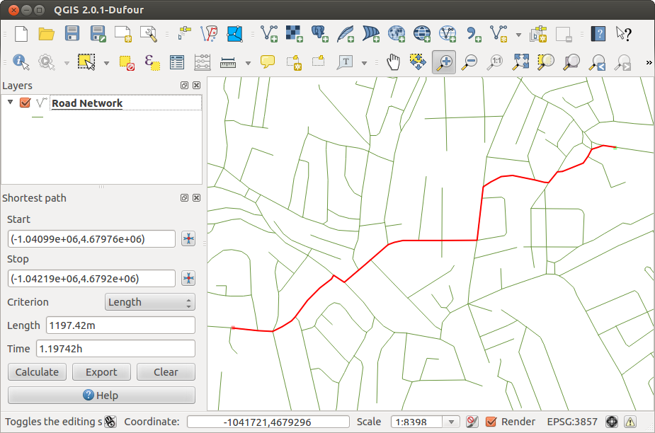
Road Graph Plugin 
主な機能:
経路,距離,旅行時間を計算する
距離または旅行時間で最適化する
経路をベクタレイヤとして出力する
道路の方向にハイライトを入れる(動作が遅いため,主にデバッグや設定確認目的に利用します)
As a roads layer, you can use any polyline vector layer in any QGIS-supported format. Two lines with a common point are considered connected. Please note, it is required to use layer CRS as project CRS while editing a roads layer. This is due to the fact that recalculation of the coordinates between different CRSs introduces some errors that can result in discontinuities, even when ‘snapping’ is used.
次に示すレイヤ属性テーブルのフィールドが利用可能です
道路区間の速度 ( 数値フィールド);
方向 (文字列にキャストできる任意の型). 一方通行の道路は前方向と逆方向があります, 両方の方向を持つ場合は両方向の道路を示します.
もしいくつかのフィールドが値を持っていないか存在しない場合,デフォルトの値が使われます.デフォルトの変更といくつかのプラグインの設定は設定ダイアログで可能です.
このプラグインの利用
After plugin activation, you will see an additional panel on the left side of the main QGIS window. Now, enter some parameters into the Road graph plugin settings dialog in the Vector ‣ Road Graph menu (see figure_road_graph_2).
Figure Road Graph 2:
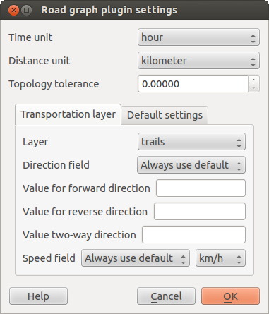
Road graph plugin settings
After setting the Time unit, Distance unit and Topology tolerance, you can choose the vector layer in the Transportation layer tab. Here you can also choose the Direction field and Speed field. In the Default settings tab, you can set the Direction for the calculation.
最後に Shortest Path パネルで 道路ネットワークレイヤ開始と終了ポイントを選択して下した後で [Calculate] をクリックして下さい.