.
ラスター地形解析プラグイン
 The Raster Terrain Analysis Plugin can be used to calculate the
slope, aspect, hillshade, ruggedness index and relief for digital elevation
models (DEM). It is very simple to handle and provides an intuitive graphical
user interface for creating new raster layers (see Figure_raster_terrain_1).
The Raster Terrain Analysis Plugin can be used to calculate the
slope, aspect, hillshade, ruggedness index and relief for digital elevation
models (DEM). It is very simple to handle and provides an intuitive graphical
user interface for creating new raster layers (see Figure_raster_terrain_1).
分析の説明:
傾斜:各セルの傾斜角を度単位で計算する(一時導関数の推定に基づく)。
傾斜方位: 説明 (反時計回りに、北方向は0から始まる) .
- Hillshade: Creates a shaded map using light and shadow to provide a more three-dimensional appearance for a shaded relief map. The output map is a Single band gray reflecting the gray value of the pixels.
起伏度指標: Riley et al. (1999) により述べられている地形の不均一性を定量的に示す. 3x3グリッドごとに全ての場所ごとに標高の変化を要約して計算します.
- Relief: Creates a shaded relief map from digital elevation data. Implemented is a method to choose the elevation colors by analysing the frequency distribution. The output map is a multiband color with three bands reflecting the RGB values of the shaded relief.
Figure Raster Terrain 1:
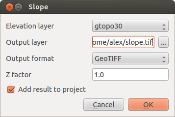
ラスター地形解析プラグイン (傾斜計算)
プラグインの利用
- Start QGIS and load the
gtopo30raster layer from the GRASS sample location. ラスター地形解析プラグインをプラグインマネージャーで読み込む (プラグインダイアログ 参照)
メニューから解析手法を選択します (例. ラスタ ‣ 地形解析 ‣ 傾斜). 傾斜 ダイアログが Figure_raster_terrain_1 のように表示されます.
出力ファイルパスおよび出力ファイルタイプを指定します。
**[OK]**をクリックします。