.
GPS Plugin
Was ist GPS?
GPS, the Global Positioning System, is a satellite-based system that allows anyone with a GPS receiver to find their exact position anywhere in the world. GPS is used as an aid in navigation, for example in airplanes, in boats and by hikers. The GPS receiver uses the signals from the satellites to calculate its latitude, longitude and (sometimes) elevation. Most receivers also have the capability to store locations (known as waypoints), sequences of locations that make up a planned route and a tracklog or track of the receiver’s movement over time. Waypoints, routes and tracks are the three basic feature types in GPS data. QGIS displays waypoints in point layers, while routes and tracks are displayed in linestring layers.
GPS-Daten aus einer Datei laden
There are dozens of different file formats for storing GPS data. The format that QGIS uses is called GPX (GPS eXchange format), which is a standard interchange format that can contain any number of waypoints, routes and tracks in the same file.
To load a GPX file, you first need to load the plugin.
Plugins ‣  Plugin Manager... opens the Plugin Manager Dialog.
Activate the
Plugin Manager... opens the Plugin Manager Dialog.
Activate the  GPS Tools checkbox. When this plugin
is loaded, a button with a small handheld GPS device will show up in the
toolbar and in Layer ‣ Create Layer ‣ :
GPS Tools checkbox. When this plugin
is loaded, a button with a small handheld GPS device will show up in the
toolbar and in Layer ‣ Create Layer ‣ :
 GPS Tools
 Create new GPX Layer
For working with GPS data, we provide an example GPX file available in the QGIS sample dataset: qgis_sample_data/gps/national_monuments.gpx. See section Beispieldaten for more information about the sample data.
- Select Vector ‣ GPS ‣ GPS Tools or click the
GPS Tools icon in the toolbar and open the
Load GPX file tab (see figure_GPS_1).
Suchen Sie den Ordner qgis_sample_data/gps/, wählen Sie die GPX-Datei national_monuments.gpx und klicken Sie [Öffnen].
Figure GPS 1:
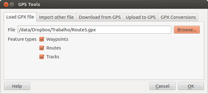
The GPS Tools dialog window 
Use the [Browse...] button to select the GPX file, then use the checkboxes to select the feature types you want to load from that GPX file. Each feature type will be loaded in a separate layer when you click [OK]. The file national_monuments.gpx only includes waypoints.
Bemerkung
GPS units allow you to store data in different coordinate systems. When downloading a GPX file (from your GPS unit or a web site) and then loading it in QGIS, be sure that the data stored in the GPX file uses WGS 84 (latitude/longitude). QGIS expects this, and it is the official GPX specification. See http://www.topografix.com/GPX/1/1/.
GPSBabel
Since QGIS uses GPX files, you need a way to convert other GPS file formats to GPX. This can be done for many formats using the free program GPSBabel, which is available at http://www.gpsbabel.org. This program can also transfer GPS data between your computer and a GPS device. QGIS uses GPSBabel to do these things, so it is recommended that you install it. However, if you just want to load GPS data from GPX files you will not need it. Version 1.2.3 of GPSBabel is known to work with QGIS, but you should be able to use later versions without any problems.
GPS-Daten importieren
Um GPS-Daten aus einer Datei, die nicht im GPX-Format vorliegt zu importieren, benutzen Sie den Reiter Aus anderer Datei importieren. Wählen Sie dann die Datei (und den Dateityp), die importiert werden soll aus, von welchem Datenformat Sie importieren möchten und wo die konvertierte GPX-Datei unter welchem Namen abgelegt werden soll. Beachten Sie, dass nicht für alle Datenformate die drei GPS-Datentypen Wegpunkte, Routen und Spuren unterstützt werden. Manchmal sind es nur ein oder zwei.
GPS-Daten von einem Empfänger herunterladen
QGIS can use GPSBabel to download data from a GPS device directly as new vector layers. For this we use the Download from GPS tab of the GPS Tools dialog (see Figure_GPS_2). Here, we select the type of GPS device, the port that it is connected to (or USB if your GPS supports this), the feature type that you want to download, the GPX file where the data should be stored, and the name of the new layer.
Figure GPS 2:
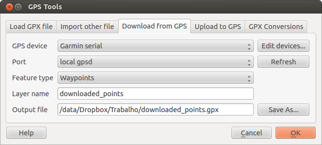
Das Downloadwerkzeug
Durch die Angabe des Typs Ihres GPS-Empfängers legen Sie fest, wie GPSBabel mit dem Gerät kommuniziert. Wenn kein vorhandener Typ mit Ihrem Empfänger funktioniert, können Sie einen eigenen, neuen Gerätetyp erstellen (vgl. Abschnitt Neues GPS-Gerät definieren).
Der Verbindungsport ist ein Dateiname oder ein anderer Name, den Ihr System als Referenz für den physischen Port benutzt, über den eine Verbindung zum GPS-Empfänger hergestellt wird. Es kann auch einfach USB sein, wenn dies von dem GPS-Gerät unterstützt wird.
- Unter Linux ist dies etwas wie /dev/ttyS0 oder /dev/ttyS1.
 Unter Windows ist dies COM1 oder COM2.
When you click [OK], the data will be downloaded from the device and appear as a layer in QGIS.
GPS-Daten auf einen Empfänger hochladen
You can also upload data directly from a vector layer in QGIS to a GPS device using the Upload to GPS tab of the GPS Tools dialog. To do this, you simply select the layer that you want to upload (which must be a GPX layer), your GPS device type, and the port (or USB) that it is connected to. Just as with the download tool, you can specify new device types if your device isn’t in the list.
This tool is very useful in combination with the vector-editing capabilities of QGIS. It allows you to load a map, create waypoints and routes, and then upload them and use them on your GPS device.
Neues GPS-Gerät definieren
There are lots of different types of GPS devices. The QGIS developers can’t test all of them, so if you have one that does not work with any of the device types listed in the Download from GPS and Upload to GPS tools, you can define your own device type for it. You do this by using the GPS device editor, which you start by clicking the [Edit devices] button in the download or the upload tab.
To define a new device, you simply click the [New device] button, enter a name, enter download and upload commands for your device, and click the [Update device] button. The name will be listed in the device menus in the upload and download windows – it can be any string. The download command is the command that is used to download data from the device to a GPX file. This will probably be a GPSBabel command, but you can use any other command line program that can create a GPX file. QGIS will replace the keywords %type, %in, and %out when it runs the command.
%type wird ersetzt durch -w, wenn Sie Wegpunkte herunterladen, -r wenn es eine Route ist und -t, wenn es sich um Spuren handelt. GPSBabel erfährt dadurch, um welchen GPS-Datentyp es sich handelt.
%in will be replaced by the port name that you choose in the download window and %out will be replaced by the name you choose for the GPX file that the downloaded data should be stored in. So, if you create a device type with the download command gpsbabel %type -i garmin -o gpx %in %out (this is actually the download command for the predefined device type ‘Garmin serial’) and then use it to download waypoints from port /dev/ttyS0 to the file output.gpx, QGIS will replace the keywords and run the command gpsbabel -w -i garmin -o gpx /dev/ttyS0 output.gpx.
Das Kommando hinaufladen wird benutzt, um die Daten auf Ihren GPS-Empfänger zu transferieren. Es werden dazu die gleichen Schlüsselworte benutzt, nur dass %in durch den Namen der hochzuladenen GPX-Datei und %out durch den Namen des Verbindungsports ersetzt wird.
Sie können mehr über GPSBabel und seine Funktionen unter der URL http://www.gpsbabel.org erlernen.
Wenn Sie einmal einen eigenen Gerätetypen erstellt haben, wird dieser in der Liste der GPS-Geräte dauerhaft angezeigt werden.
Downloaden von Punkten/Spuren von GPS Einheiten
Wie in vorigen Abschnitten beschrieben verwendet QGIS GPSBabel um Punkte/Spuren direkt ins Projekt herunterzuladen. QGIS wird mit einem vordefinierten Profil zum Downloaden von Garmingeräten zur Verfügung gestellt. Unglücklicherweise gibt es dort einen bug der es unmöglich macht andere Profile zu erstellen, also ist das direkte Downloaden in QGIS mithilfe der GPS Werkzeuge im Moment auf Garmin UBS Einheiten begrenzt.
Garmin GPSMAP 60cs
MS Windows
Installieren Sie Garmin USB Treiber von http://www8.garmin.com/support/download_details.jsp?id=591
Verbinden Sie die Einheit. Öffnen Sie GPS Werkzeuge und verwenden Sie type=garmin serial und port=usb:. Füllen Sie die Felder Layername und Ausgabedatei aus. Manchmal scheint es Probleme beim Speichern in einen bestimmten Ordner zu geben, wenn Sie etwas wie c:\temp verwenden funktioniert es für gewöhnlich.
Ubuntu/Mint GNU/Linux
Es wird zuerst ein Eintrag über die Rechte des Gerätes benötigt, wie beschrieben auf https://wiki.openstreetmap.org/wiki/USB_Garmin_on_GNU/Linux. Sie können versuchen eine Datei /etc/udev/rules.d/51-garmin.rules zu erstellen, die diese Regel enthält.
ATTRS{idVendor}=="091e", ATTRS{idProduct}=="0003", MODE="666"
Danach ist es nötig sicher zu gehen das das garmin_gps Kernelmodul nicht geladen ist
rmmod garmin_gps
und dann können Sie die GPS Werkzeuge verwenden. Leider scheint es einen bug zu geben und QGIS friert mehrere Male ein bevor die Operation gut funktioniert.
BTGP-38KM Datenlogger (nur Bluetooth)
MS Windows
Der bereits erwähnte Bug lässt es nicht zu, dass Daten innerhalb von QGIS heruntergeladen werden, also müssen Sie GPSBabel aus der Kommandozeile heraus oder mit Hilfe seiner Schnittstelle verwenden.
gpsbabel -t -i skytraq,baud=9600,initbaud=9600 -f COM9 -o gpx -F C:/GPX/aaa.gpx
Ubuntu/Mint GNU/Linux
Verwenden Sie den gleichen Befehl (oder Einstellungen wenn Sie die GPSBabel GUI verwenden) wie in Windows. Unter Linux ist vielleicht üblich eine Nachricht wie folgt zu erhalten
skytraq: Too many read errors on serial port
es ist einfach eine Frage des aus- und anschalten des Dateloggers und es erneut zu versuchen.
BlueMax GPS-4044 Datenlogger (sowohl BT als auch USB)
MS Windows
Bemerkung
Es muss seine Treiber installieren bevor man es unter Windows 7 verwendet. Sehen Sie in den Herstellerseiten für den richtigen Download nach.
Downloaden mit GPSBabel, mit USB und BR, gibt immer einen Fehler heraus wie
gpsbabel -t -i mtk -f COM12 -o gpx -F C:/temp/test.gpx
mtk_logger: Can't create temporary file data.bin
Error running gpsbabel: Process exited unsucessfully with code 1
Ubuntu/Mint GNU/Linux
Mit USB
Nachdem Sie das Kabel angeschlossen haben verwenden Sie den dmesg Befehl um zu verstehen welcher Port benutzt wird, zum Beispiel /dev/ttyACM3. Benutzen Sie dann wie immer GPSBabel aus der Kommandozeile oder der GUI.
gpsbabel -t -i mtk -f /dev/ttyACM3 -o gpx -F /home/user/bluemax.gpx
Mit Bluetooth
Verwenden Sie Blueman Device Manager um das Gerät zu verbinden und machen Sie es über einen Systemport zugänglich, starten Sie dann GPSBabel.
gpsbabel -t -i mtk -f /dev/rfcomm0 -o gpx -F /home/user/bluemax_bt.gpx