.
Rastergeländeanalyse-Erweiterung
 The Raster Terrain Analysis Plugin can be used to calculate the
slope, aspect, hillshade, ruggedness index and relief for digital elevation
models (DEM). It is very simple to handle and provides an intuitive graphical
user interface for creating new raster layers (see Figure_raster_terrain_1).
The Raster Terrain Analysis Plugin can be used to calculate the
slope, aspect, hillshade, ruggedness index and relief for digital elevation
models (DEM). It is very simple to handle and provides an intuitive graphical
user interface for creating new raster layers (see Figure_raster_terrain_1).
Description of the analysis:
Neigung: Berechnet den Neigungswinkel für jede Zelle in Grad (beruht auf Ableitung erster Ordnung).
Perspektive: Berechnung der Exposition. Beginnend mit 0 für Nord und dann in Grad gegen den Uhrzeigersinn.
- Hillshade: Creates a shaded map using light and shadow to provide a more three-dimensional appearance for a shaded relief map. The output map is a Single band gray reflecting the gray value of the pixels.
Rauhigkeitsindex: Eine quantitative Bestimmung der Heterogenität eines Geländes beschrieben durch Riley et al. (1999). Es wird für jeden Ort mit einem 3x3 Pixel Fenster berechnet.
- Relief: Creates a shaded relief map from digital elevation data. Implemented is a method to choose the elevation colors by analysing the frequency distribution. The output map is a multiband color with three bands reflecting the RGB values of the shaded relief.
Figure Raster Terrain 1:
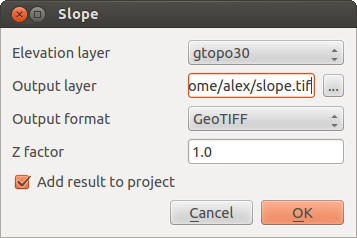
Rastergeländeanalyse-Erweiterung (Neigungsberechnung)
Das Plugin anwenden
- Start QGIS and load the gtopo30 raster layer from the GRASS sample location.
Laden Sie die Rastergeländeanalyse-Erweiterung im Plugin Manager (siehe Abschnitt Der Erweiterungen Dialog).
Wählen Sie eine Analysemethode (z.B.: Raster ‣ Geländeanalyse ‣ Neigung). Der Neigung Dialog erscheint wie in Figure_raster_terrain_1 gezeigt.
Geben Sie eine Ausgabedatei mit Pfad und Dateiformat an.
Klicken Sie [OK].