Straßengraph Plugin
The Road Graph Plugin is a C++ plugin for QGIS, that calculates the shortest path between two points on any polyline layer and plots this path over the road network.
Figure Road Graph 1:
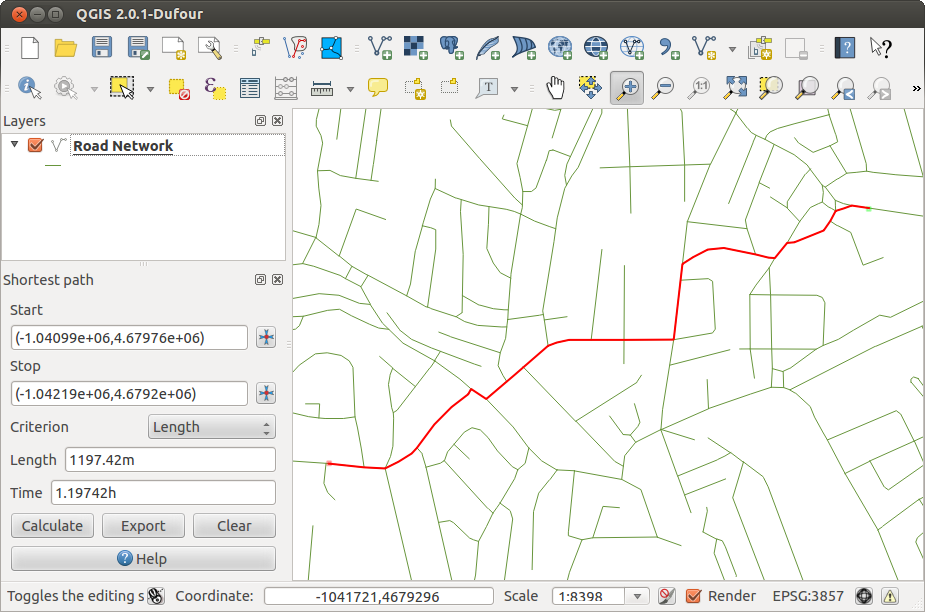
Road Graph Plugin 
Hauptfunktionen:
Berechnung der Route, seiner Länge und der Reisezeit
Optimierung durch Länge oder Reisezeit
Export der Route als Vektorlayer
Anzeigen der Vektorrichtungen (diese Funktion ist langsam und wird meist nur zum Testen verwendet)
As a roads layer you can use any polyline vector layer in any QGIS supported format. Two lines with a common point are considered connected. Please note, it is required to use layer CRS as project CRS while editing roads layer. This is due to the fact that recalculation of the coordinates between different CRS introduce some errors that can result in discontinuities, even when ‘snapping’ is used.
In der Attributtabelle des Layera können folgende Spalten genutzt werden:
Geschwindigkeit als numerische Spalte;
Richtung in jedem Datentyp, der mit String kompatibel ist. Wenn eine Spalte benutzt wird, bezieht sie sich auf beide Richtungen, ansonsten wird unterschieden
Wenn einige Zeilen keine Werte haben, werden die Defaultwerte verwendet. Sie können bei Bedarf geändert werden, gemeinsam mit ein paar weiteren Einstellungsmöglichkeiten im Dialog Straßengraph-Einstellungen im Menü Vektor –> Straßengraph.
Verwendung der Erweiterung
After plugin activation you will see an additional panel on the left side of the main QGIS window. Now make some definitions to the Road graph plugin settings dialog in the menu Vector ‣ Road Graph (see figure_road_graph_2).
Figure Road Graph 2:
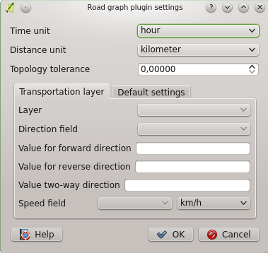
Road graph plugin settings
After setting the Time unit, Distance unit and Topology tolerance you can choose the vector layer in the Transportation layer tab. Here you can also choose the Direction field and Speed field. In the Default settings tab you can set the Direction for the calculation.
Finally in the Shortest Path panel select a Start and a Stop point in the road network layer and click on [Calculate].