QGIS Browser
The QGIS Browser is a new panel in QGIS that lets you easily navigate in your database. You can have access to common vector files (e.g. ESRI shapefile or MapInfo files), databases (e.g.PostGIS or MSSQL Spatial) and WMS/WFS connections. You can also view your GRASS data (to get the data into QGIS see GRASS GIS Integration).
Figure browser 1:
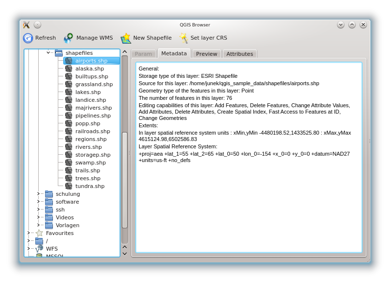
Qgis browser as a standalone application to view metadata, preview and attributes 
Use QGIS Browser to preview your data. The drag and drop function makes it easy to get your data into the Map view and the Map legend.
- Activate QGIS Browser: Right-click on the tool bar and click
 Browser.
 - Drag the panel into the legend window.
- Klick on the Browser tab.
- Browse in your database and choose the shapefile folder from qgis_sample_data.
- Press the Shift key and klick on airports.shp and alaska.shp .
- Press the left mouse button then drag and drop the files into the map canvas.
- Right-click on a layer and choose Set project CRS from layer. For more information see Working with Projections.
- Click on
 Zoom Full to make the layers
visible.
Zoom Full to make the layers
visible.
It’s also possible to run QGIS Browser as a standalone application.
Start qgis browser
- Type in “qbrowser” at a command prompt.
 Start QGIS browser using the Start menu or desktop shortcut, or
double click on a QGIS project file.
Start QGIS browser using the Start menu or desktop shortcut, or
double click on a QGIS project file. QGIS browser is not available yet from your your Applications folder.
However it can easily be made available. In Finder use
Go ‣ Go to map... and use it to find the folder
/Applications/QGIS.app/Contents/MacOS/bin.
Use the key combination option - command and drag qbrowser.app
while holding down the left mouse button to the Applications folder.
This will create a link that you can use to start QGIS browser.
QGIS browser is not available yet from your your Applications folder.
However it can easily be made available. In Finder use
Go ‣ Go to map... and use it to find the folder
/Applications/QGIS.app/Contents/MacOS/bin.
Use the key combination option - command and drag qbrowser.app
while holding down the left mouse button to the Applications folder.
This will create a link that you can use to start QGIS browser.
In figure_browser_standalone_metadata you can see the enhanced functionality of Qgis browser. The Param tab provides the details of your connection based datasets like PostGIS or MSSQL Spatial. The Metadata tab contains general information about the file (see Metadata Tab). With the Preview tab you can have a look at your files without importing them into your QGIS project. It’s also possible to preview the attributes of your files in the Attributes tab.