` `
Complemento administrador de BBDD
The DB Manager Plugin is officially part of the QGIS core and is intended to be
the main tool to integrate and manage spatial database formats supported by QGIS
(PostGIS, SpatiaLite, GeoPackage, Oracle Spatial, Virtual layers) in one user interface.
The  DB Manager Plugin provides several features.
You can drag layers from the QGIS Browser into the DB Manager, and it will import your layer
into your spatial database. You can drag and drop tables between spatial databases
and they will get imported.

Diálogo del complemento administrador de BBDD
El menú Base de datos permite conectar a una base de datos existente, para iniciar la ventana de SQL y para finalizar el componente de Administrador de BBDD. Una vez que este conectado a la base de datos existente, los menús Esquema y Tabla aparecerá de forma adicional.
EL menú Esquema incluye herramientas para crear y eliminar (vaciar) esquemas y, si la topología esta disponible (e.j., PostGIS 2), iniciar un TopoViewer.
El menú Tabla permite crear y editar tablas y eliminar tablas y vistas. También es posible vaciar tablas y moverlas de un esquema a otro. Como función adicional, se puede realizar un VACUUM y luego un ANALYZE para cada tabla seleccionada. VACUUM simplemente recupera espacio y hace que este disponible para reusarlo. ANALYZE actualiza las estadisticas para determinar la forma más eficiente de ejecutar una consulta. Finalmente, se pueden importar capas/archivos, si estan cargados en QGIS o existen en el sistema de archivos. Y se puede exportar tablas de la base de datos a archivo vectorial con la función “Exportar archivo”.
The Tree window lists all existing databases supported by QGIS. With a double-click, you can connect to the database. With the right mouse button, you can rename and delete existing schemas and tables. Tables can also be added to the QGIS canvas with the context menu.
Si se está conectado a una base de datos, la ventana principal del Administrador de BBDD ofrece tres pestañas. La pestaña Info proporciona información acerca de la tabla y su geometría, así como de los campos existentes, limitaciones e índices. También permite que ejecute Vacuum Analyze y crear índices espaciales en una tabla seleccionada, si no está ya hecho. La pestaña de Tabla muestra todos los atributos y la pestaña Vista preliminar representa las geometrías como vista previa.
Trabajar con la ventana SQL
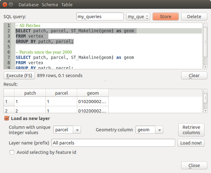
You can also use the DB Manager to execute SQL queries against your spatial database and then view the spatial output for queries by adding the results to QGIS as a query layer. It is possible to highlight a portion of the SQL and only that portion will be executed when you press F5 or click the Execute (F5) button.

Executing SQL queries in the DB Manager SQL window
Nota
The SQL Window can also be used to create Virtual Layers. In that case, instead of selecting a database, select QGIS Layers under Virtual Layers before opening the SQL Window. See Creating virtual layers for instructions on the SQL syntax to use.